Article: Obsidian and Blood setting, 1: the Valley of Mexico
This is part 1 of a series of posts on the setting of my Aztec fantasy series Obsidian and Blood, as a leadup to the release of Book 1, Servant of the Underworld, published by Angry Robot/HarperCollins (more information here, including excerpts and a book trailer). You can find part 2 (the city of Tenochtitlan and the myth of origins) here, part 3 (the Sacred Precinct and Mexica religion) here, and part 4 (Acatl and death in Mexica religion) here.
Any questions or comments welcome!
1. The Valley of Mexico (and Aztec Empire)
Who are the Aztecs? The first question you’ll ask yourself when you read the book is why I refer to them by the name of “Mexica”. What’s with that, you ask? Well, the Aztecs never called themselves Aztecs. That was a name foisted on them later by the Spanish: it comes from Aztlan, the White Place (which the Aztecs listed as their place of origin and which you can find in hymns within Servant of the Underworld), but they never used it that way. The name they used for themselves was either Colhua Mexica or Tenochca. The second refers to Tenoch, their mythical first leader, who gave his name to Tenochtitlan (it’s a little more complicated than that actually, but I’ll get to that in part 2 of those posts). I used the first, shortening it a bit to make things easier.
No one is sure where “Mexica” comes from exactly: a popular hypothesis is that it comes from Metzli, which means “moon” in the Nahuatl language; another explanation is that it derives from the secret name of their tribal god, Mexitl.
To understand where the “Colhua” bit comes from, you have to understand that the Aztecs were late comers to the Basin of Mexico. The area had been inhabited for centuries if not millenia; and it was fundamentally different from the basin as it is now. For starters, there was a lot more water: see the map below for reference (Tenochtitlan, the island in the centre of the lake, is about where Mexico’s railway station is today). The Spanish drained it away to control the flooding, but before they came, the whole place was basically a marsh. It’s not for nothing that the Aztecs called the Basin of Mexico Anahuac, which means “The Place Between the Waters”: they were water people, just as their cousins the Maya to the South of Mexico were jungle people.
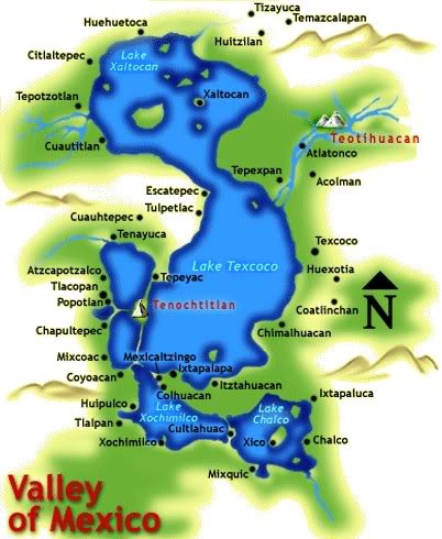
When the Aztecs came on-stage in the mid-13th Century, many civilisations had already come and gone: it’s a small area (the map covers about 40-50km over 30km), but it’s a fertile one, and a series of city-states fought each other for its political and economical domination. They each tried to legitimise their power by availing themselves of the legacy of the Toltecs, a semi-legendary civilisation said to have been ruled by the benevolent god Quetzalcoatl, the Feathered Serpent. The Aztecs were no strangers to this policy, and their first emperor married a princess from Colhuacan in order to establish themselves on the political map.
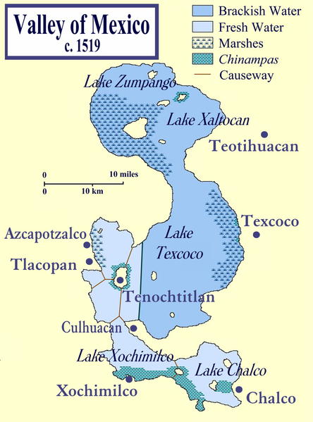
By the time 1480, the year of the novel, rolled around, the Basin of Anahuac had become radically different: the city-states warring for domination had been replaced by a network of tribute-paying vassals. The tribute flowed to the Triple Alliance, established in 1428: it was made up of Tenochtitlan, the capital of the Mexica, Texcoco, and Tlacopan (see the second map). Though Tlacopan had started out as an equal-rights partner, it gradually lost its importance, and the Triple Alliance was soon steered by only two cities, Tenochtitlan and Texcoco. They sent joint armies to war every year, and grew rich on the astonishing amount of tribute sent them from every province, which included quetzal feathers, jaguar skins, adorned suits but also firewood, seashells, cotton…
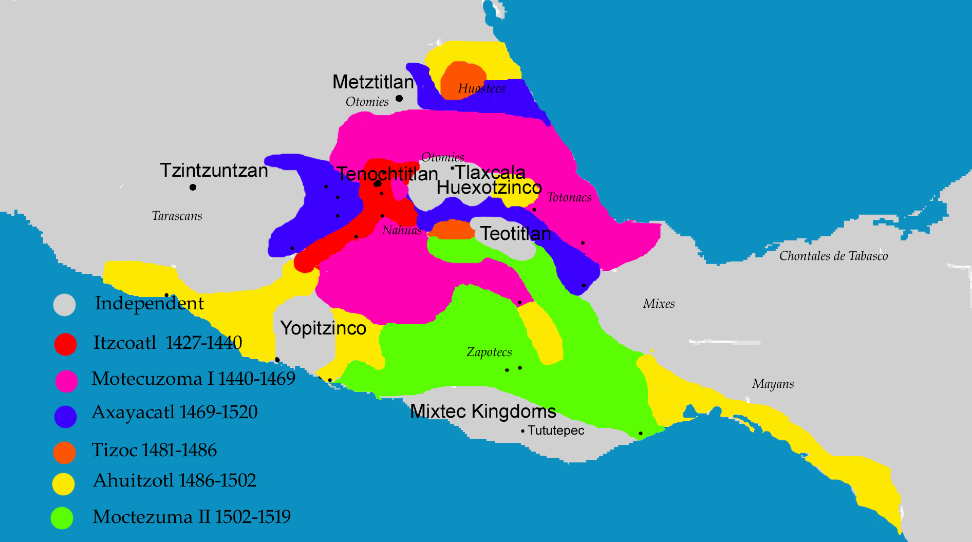
A quick word about the Aztec Empire. By geographical standards, it was not that huge: to give you an idea, the Alliance didn’t control the whole of the basin until 1465, when they conquered Chalco (bottom right of the map) after a prolonged war. To be fair, they had started expanding out of the basin beforehand, and Chalco was the last troublesome province left within.
You can see the actual expansion of the Empire at the date of the novel below. It includes that basin, and territories around it: the red, purple and dark blue areas (you can sort of recognise part of the basin in the red zone around Tenochtitlan). It’s a little deceptive, because recently conquered areas tended to rebel and need more military interventions by the Mexica–so it’s not a map of political divisions as stable as, say, the Roman Empire. At its height under the reign of Moctezuma II in 1519, the Empire covered about 500,000 square kilometers, less than the total surface of France today. Again, not that big a place–it barely reached down to the Maya in the south of Mexico.
It didn’t help the Mexica conquests, though, that most of their territory was either mountains or marshes, which the armies had to walk on foot or navigate by boat (it’s often said that the Mesoamericans had no wheel, which isn’t quite true. They had the wheel on children’s toys, but in terrain so mountainous they judged it pointless to bother with chariots and other wheeled conveyances). Similarly, the basin of Anahuac was one huge lake (in fact, five separate lakes all merging into one at the rainy season) surrounded by mountains. It’s a testament to the Mexica ingenuity that they managed to field armies out of it.
The basin of Anahuac was the heart of the Empire and its most tightly controlled zone. It was a densely populated area. It’s hard to estimate the population, but most estimations are between 1 and 2.5 million inhabitants in 1519 (the date the Spanish arrived on the scene). For the area, this is pretty big: to give you an idea, Paris, one of the biggest cities in the 15th Century, held about 200,000 inhabitants.
Other places of importance in the basin:
-Teotihuacan (east of the map), “The Place where the Gods are Born”, was the site of an earlier civilisation which had grown to power by controlling the obsidian mines. It collapsed long before the Mexica, in the 7th or 8th Century AD–but the monuments that remained (including the massive pyramids of the Sun and of the Moon) led the Mexica to believe that this was a sacred place–the place where the sun had risen into the sky at the beginning of the current age. It was a city in its own right as well as a place of pilgrimage.
-there is a green line separating the lake in two different parts: this is a dyke built by Nezahualcoyotl, ruler of Texcoco, in order to separate the saltwater from the freshwater. It wasn’t enough to ensure a supply of water to the city of Tenochtitlan: an aqueduct had to be built, which brought water from the springs to the west.
-the chinampas, or chinamitls, or floating gardens: again, what little land was available wasn’t enough to support the population of Tenochtitlan, so the Mexica added some. The chinamitls are artificial islands made of the muck of the lake, held into place by wooden stakes driven into the lakebed (and by trees if necessary). They formed a dense grid of very productive fields, occasionally topped up by more muck in order to preserve the fertility.
-Coyoacan (on the first map, bottom left) is the place of birth of my main character Acatl.
That’s it for today. Tomorrow: the city of Tenochtitlan and the myth of Mexica origins.
0 comments
Jeff Spock
A wealth of interesting stuff. I know much more about Mayan civilization than Aztec, so this is new to me. About the only grounding I had in all this are the city names, because you get them by default when you choose to play the Aztecs in Civilization 🙂
I’m wondering how you’ll manage to avoid name confusion in your novel, because names either seem very similar (Cuauhtepec / Cuautetlan / Chapultepec / Cultlahuac) or very complex (Nezahualcoyotl).
Looking forward to the next installment…
Spencer Ellsworth
This is fascinating and a very nice simple introduction. I’ve been reading an encyclopedic work about Mesoamerican society and I just can’t get my head around a society without beasts of burden or chariot/carts.
aliette
Jeff: I’ve seen the city names in Civilization as well 🙂
I have three basic strategies for avoid name confusion: the first is shamelessly manipulating the narrative to make sure that no two similar names will end up too close to each other. The second is to translate when I can (my editor Marc Gascoigne was the one who originally suggested this for the names of the gods, and it’s quite handy: it’s much easier to parse “The Feathered Serpent” than Quetzalcoatl).
And the third is to fudge within reasonable limits: I can choose characters’ names to be short even though it’s not strictly historically accurate, limit the use of honorifics (which are tacked on as suffixes to the end of already kilometric names), and finally modify some of the names if they’re really too unwiedly. I haven’t done it yet, but I’m seriously tempted for the second book (I have one Nezahualpilli-tzin, which is a horrible mouthful to pronounce, and chopping a few syllables would help him reintegrate the realm of characters with names that can be memorised).
aliette
Spencer: aw, thanks! The one I have trouble getting my head around is the lack of beasts of burdens. Given the lie of the land, I can understand why carts wouldn’t be handy. A mule or a donkey, on the other hand… Guess they were just unlucky not to have those animals within reach).
Silvia
Pretty much until the 19th century Aztecs were (correctly) called Mexica. I believe an American historian changed their name then to the inaccurate Aztec.
It’s pretty easy to understand a society without beasts of burden, btw, if you’ve lived there. Specially Tenochtitlan, which was a water-based city with the canals criss-crossing the entire metropolis.
In Baja California, where I am from, getting across some of deep mountain areas on a mule is difficult. A car is impossible and a cart would be the same thing: worthless.
I guess a llama would have been useful.
But you, know, Mexica couriers were very quick, so I guess they managed. 🙂
meg
This was really interesting. I’m a freshman Archaeology undergrad. I loved learning about Mesoamerica in my 101 class and I thought it would be a incredibly fascinating culture and setting for a novel, so I’m really excited to find out about your book and I’m looking forward to reading it.
aliette
Silvia: I had no idea the mountains were that hard to cross. Wow. No wonder they preferred courier systems.
I’d heard something like that about the use of the name “Aztec”–sigh. Amazing how far the erroneous word spread in a century (and in every language, too).
Meg: thanks, glad you find it interesting! Archaelogy’s been a longtime fascination, even though I had to eventually make a choice between that and engineering…
Cuauhtli
Hey My names Cuauhtli and i’m Mexicatl (Aztec) my father is full blood and i know ALOT about our history and culture and i know that there is a very Euro-centric view of My people and that most htings taught today are wrong. The name for our people Mexica comes from one of our leaders His name was Mexihtli Witzilopochtli. Mexica translated is “The people of Mexihtli” also the word Mexico means “In the place of Mexihtli” Unless you can speak Nahuatl and can understand our Numeral system and Pictographs you will have alot of trouble understanding our history, culture and the way we lived. We did also have a much more vast area then Tenochtitlan, our people and language spread as far from Aztlan (Present day Utah) to Nikananawak (Present day Nicaragua) we occupied Amalpan (Belize) Atenantitech (Honduras) Cuauhtemalan (Guatemala) and Cuzcatlan (El Salvador) and came into contact and traded with alot of other Ixachilankah (Natives).
Sorry. Comments are closed on this entry.